

home about us archaeology excursions sea offers territory contact link gallery

|
The territory of Dorgali in the east-central part of the island has the very essence of Sardinia within its 225 square kilometres. The landscape varies through a succession of green valleys and hills, forests and rugged mountains, with hidden mysterious caves and dolinas (natural depressions). On the coast, imposing limestone cliffs overlook the crystal-clear sea and luxuriant vegetation alternates with bare rock around coves and white sand beaches. The territory is so well-endowed with its geology and archaeology, its plants and animals, that it can satisfy many interests. This ancient land is made up of granite, limestone and basalt rocks, and they have created captivating landscapes. Each rock formation is characterized by its flora: in the basalt and granite plateaus there are uncultivated pastures and Mediterranean maquis made up of trees, shrubs and plants such as mastic, wild olive, euphorbia, holm-oak, arbutus, myrtle and many others. In the limestone highlands there are thick forests of juniper and holm-oaks. Among them, the beautiful "cuiles" (traditional shepherds’ huts built of limestone rocks and juniper trunks) stand out with all their charm. This wild and unspoiled environment is the natural habitat of many species of animals including rare fauna that still survives here. The territory is a precious attraction for nature lovers, but also for those who are interested in archaeology. Indeed, it has a particular archaeological wealth, offering a wide choice of monuments and archaelogical sites dating from the Neolithic age to the Middle Ages. Many caves have been used as dwellings or as tombs since the most remote antiquity, constituting an important archeological treasure together with the domus de janas, dolmens, giants’ tombs, nuraghi, nuragic villages and wells. These sites are scattered throughout the territory, even in the most inaccessible mountain areas and on the coasts, where remains left by Punic and Roman conquerors are still visible. The sites have given up a remarkable quantity of archaeological relics. Many can be seen in the Archaeological Museum of Dorgali and they help to reconstruct much of the history of this territory which, however, still contains a lot of hidden treasures and surprises.
|

|
From the 1950s Dorgali and Cala Gonone have been among the most well-known places in Sardinia. Much of Dorgali’s importance is based on the presence of Cala Gonone, the attractive seaside locality connected to the town in 1925 by a road tunnel. The first people to colonize the area of Cala Gonone came in the Nuragic age, and more waves came in Roman times and in the Middle Ages. Around 1700 the little port became a point for the exchange of commodities with the mainland, and in the 19th century, families from Nuoro began to spend their summer holidays here, launching its new role as a seaside resort. |
|
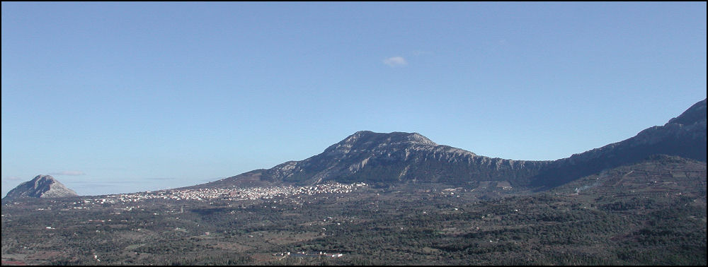
DORGALI: one of the most interesting towns of Sardinia, it is on the eastern border of the Barbagia and its environment has many unique characteristics. This uniqueness was the reason why more than a quarter of the town’s territory (60sqkm) was contributed towards creating the Gennargentu and Gulf of Orosei Park. Set at the foot of Mount Bardia, Dorgali is visible from many peaks in the Barbagia, and shows in the distance as a white site on a green background.
|

|
CALA GONONE: the tourist centre is reached by the road tunnel cut through the saddle formed on the north by Mount Bardia and on the south by Mount Tului. At the end of the tunnel, the village comes into view 400 metres below, beyond a great forest of evergreen oaks. At the centre of the Gulf of Orosei, this is the sea border of the Supramonte and for more than 40 kilometres, from the beach of Cartoe south to Pedra Longa at Baunei, virtually all this coastline is accessible only on foot or by boat.
|